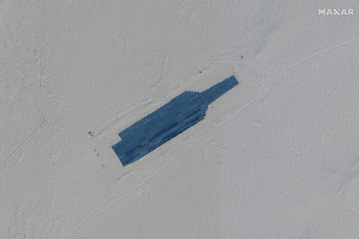
The key capability is autonomous final target acquisition by the missile at a range of tens of km -- i.e., the distance the ship can move during missile flight time after launch. State of the art air to air missiles already do this in BVR (Beyond Visual Range) combat. Note, they are much smaller than anti-ship missiles, with presumably much smaller radar seekers, yet are pursuing a smaller, faster, more maneuverable target (enemy aircraft).
It seems highly likely that the technical problem of autonomous targeting of a large surface ship during final missile approach has already been solved some time ago by the PLARF.
With this capability in place one only has to localize the carrier to within few x 10km for initial launch, letting the smart final targeting do the rest. The initial targeting location can be obtained through many methods, including aircraft/drone probes, targeting overflight by another kind of missile, LEO micro-satellites, etc. Obviously if the satellite retains coverage of the ship during the entire attack, and can communicate with the missile, even this smart final targeting is not required.
See LEO SAR, hypersonics, and the death of the naval surface ship:
In an earlier post we described how sea blockade (e.g., against Japan or Taiwan) can be implemented using satellite imaging and missiles, drones, AI/ML. Blue water naval dominance is not required.
PLAN/PLARF can track every container ship and oil tanker as they approach Kaohsiung or Nagoya. All are in missile range -- sitting ducks. Naval convoys will be just as vulnerable.
Sink one tanker or cargo ship, or just issue a strong warning, and no shipping company in the world will be stupid enough to try to run the blockade.
USN guy: We'll just hide the carrier from the satellite and missile seekers using, you know, countermeasures! [Aside: don't cut my carrier budget!]
USAF guy: Uh, the much smaller AESA/IR seeker on their AAM can easily detect an aircraft from much longer ranges. How will you hide a huge ship?
USN guy: We'll just shoot down the maneuvering hypersonic missile using, you know, methods. [Aside: don't cut my carrier budget!]
Missile defense guy: Can you explain to us how to do that? If the incoming missile maneuvers we have to adapt the interceptor trajectory (in real time) to where we project the missile to be after some delay. But we can't know its trajectory ahead of time, unlike for a ballistic (non-maneuvering) warhead.


No comments:
Post a Comment